.JPG)
.JPG)
.JPG)
.JPG)
.JPG)
.JPG)
.JPG)
.JPG)
.JPG)
.JPG)
.JPG)
.JPG)
.JPG)
.JPG)
.JPG)
|
|
Alyogyne pinoniana | Alyogyne pinoniana |
|
|
|
|
| Description:Flower | Description:Leaf | |
| Location:Lake George, Cue, Western Australia | Location:Lake George, Cue, Western Australia | |
| GPS coordinates:27˚ 34.915S, 117˚ 54.058E | GPS coordinates:27˚ 34.915S, 117˚ 54.058E | |
| Date of photo:30 August 2015 | Date of photo:30 August 2015 | |
| Field No.:3533 | Field No.:3533 | |
| Alyogyne pinoniana | Alyogyne pinoniana | |
|
|
|
|
| Description:Flower and leaves | Description:Flower and leaves | |
| Location:Lake George, Cue, Western Australia | Location:Lake George, Cue, Western Australia | |
| GPS coordinates:27˚ 34.915S, 117˚ 54.058E | GPS coordinates:27˚ 34.915S, 117˚ 54.058E | |
| Date of photo:30 August 2015 | Date of photo:30 August 2015 | |
| Field No.:3533 | Field No.:3533 | |
| Alyogyne pinoniana | Alyogyne pinoniana | |
|
|
|
|
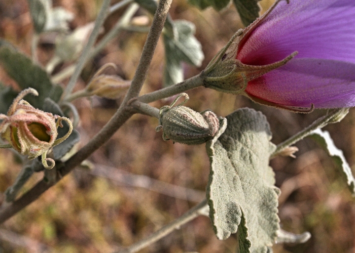
| Description:Plant in habitat on roadside | Description:Bud | |
| Location:Lake George, Cue, Western Australia | Location:Lake George, Cue, Western Australia | |
| GPS coordinates:27˚ 34.915S, 117˚ 54.058E | GPS coordinates:27˚ 34.915S, 117˚ 54.058E | |
| Date of photo:30 August 2015 | Date of photo:30 August 2015 | |
| Field No.:3533 | Field No.:3533 | |
| Alyogyne pinoniana | Alyogyne pinoniana | |
|
|
|
|
| Description:Flower | Description:Plant | |
| Location:168K N of Laverton, Great Central Road, Western Australia | Location:168K N of Laverton, Great Central Road, Western Australia | |
| GPS coordinates:27˚52.6480S, 123°42.3050E | GPS coordinates:27˚52.6480S, 123°42.3050E | |
| Date of photo:28 August 2016 | Date of photo:28 August 2016 | |
| Field No.:5645 | Field No.:5645 | |
| Alyogyne pinoniana | Alyogyne pinoniana | |
|
|
|
|
| Description:Flower - side view | Description:Leaf | |
| Location:168K N of Laverton, Great Central Road, Western Australia | Location:168K N of Laverton, Great Central Road, Western Australia | |
| GPS coordinates:27˚52.6480S, 123°42.3050E | GPS coordinates:27˚52.6480S, 123°42.3050E | |
| Date of photo:28 August 2016 | Date of photo:28 August 2016 | |
| Field No.:5645 | Field No.:5645 | |
| Alyogyne pinoniana | Alyogyne pinoniana | |
|
|
|
|
| Description:Plant in habitat | Description:Mass flowering after a fire | |
| Location:69K S of Hanns Tabletop Hill, Connie Sue Highway, Western Australia | Location:5K S of Neale Junction Nature Reserve, Connie Sue Highway, Western Australia | |
| GPS coordinates:27˚40.5260S 126˚09.5170E | GPS coordinates:28˚41.4900S 125˚47.9810E | |
| Date:28 September 2018 | Date:29 September 2018 | |
| Field No.:6773 | Field No.:6816A | |
| Alyogyne pinoniana | Alyogyne pinoniana | |
|
|
|
|
| Description:Leaf | Description:Leaf - underside | |
| Location:69K S of Hanns Tabletop Hill, Connie Sue Highway, Western Australia | Location:69K S of Hanns Tabletop Hill, Connie Sue Highway, Western Australia | |
| GPS coordinates:27˚40.5260S 126˚09.5170E | GPS coordinates:27˚40.5260S 126˚09.5170E | |
| Date:28 September 2018 | Date:28 September 2018 | |
| Field No.:6773 | Field No.:6773 | |
| Alyogyne pinoniana | Alyogyne pinoniana | |
|
|
|
|
| Description:Flower | Description:Flower - side view | |
| Location:69K S of Hanns Tabletop Hill, Connie Sue Highway, Western Australia | Location:69K S of Hanns Tabletop Hill, Connie Sue Highway, Western Australia | |
| GPS coordinates:27˚40.5260S 126˚09.5170E | GPS coordinates:27˚40.5260S 126˚09.5170E | |
| Date:28 September 2018 | Date:28 September 2018 | |
| Field No.:6773 | Field No.:6773 |
References (accessed 13 December 2018):
Image use policy 
This work is licensed under a
Creative Commons Attribution-Noncommercial 2.5 Australia License.
Page created 17 October 2015
Page edited 13 December 2018
© Roger Fryer and Jill Newland 2015 - 2018