.JPG)
.JPG)
.JPG)
.JPG)
.JPG)
.JPG)
.JPG)
.JPG)
.JPG)
.JPG)
.JPG)
.JPG)
.JPG)
.JPG)
| Atalaya hemiglauca | Atalaya hemiglauca | |
|
|
|
|
| Description:Flowers | Description:Flowers | |
| Location:10K N of the Lynd, North Queensland | Location:86K N of Bourke, New South Wales | |
| GPS coordinates:18°49.6450S, 144°34.8250E | GPS coordinates:29°22.9720S, 145°50.7720E | |
| Date of photo:22 September 2018 | Date of photo:29 October 2018 | |
| Field No.:6720 | Field No.:7610 | |
| Atalaya hemiglauca | Atalaya hemiglauca | |
|
|
|
|
| Description:Flowers - side view | Description:Flowering tree | |
| Location:10K N of the Lynd, North Queensland | Location:86K N of Bourke, New South Wales | |
| GPS coordinates:18°49.6450S, 144°34.8250E | GPS coordinates:29°22.9720S, 145°50.7720E | |
| Date of photo:22 September 2018 | Date of photo:29 October 2018 | |
| Field No.:6720 | Field No.:7610 | |
| Atalaya hemiglauca | Atalaya hemiglauca | |
|
|
|
|
| Description:Flowering tree | Description:Flowers and leaves | |
| Location:10K N of the Lynd, North Queensland | Location:86K N of Bourke, New South Wales | |
| GPS coordinates:18°49.6450S, 144°34.8250E | GPS coordinates:29°22.9720S, 145°50.7720E | |
| Date of photo:22 September 2018 | Date of photo:29 October 2018 | |
| Field No.:6720 | Field No.:7610 | |
| Atalaya hemiglauca | Atalaya hemiglauca | |
|
|
|
|
| Description:Leaf | Description:Leaf - underside | |
| Location:10K N of the Lynd, North Queensland | Location:10K N of the Lynd, North Queensland | |
| GPS coordinates:18°49.6450S, 144°34.8250E | GPS coordinates:18°49.6450S, 144°34.8250E | |
| Date of photo:22 September 2018 | Date of photo:22 September 2018 | |
| Field No.:6720 | Field No.:6720 | |
| Atalaya hemiglauca | Atalaya hemiglauca | |
|
|
|
|
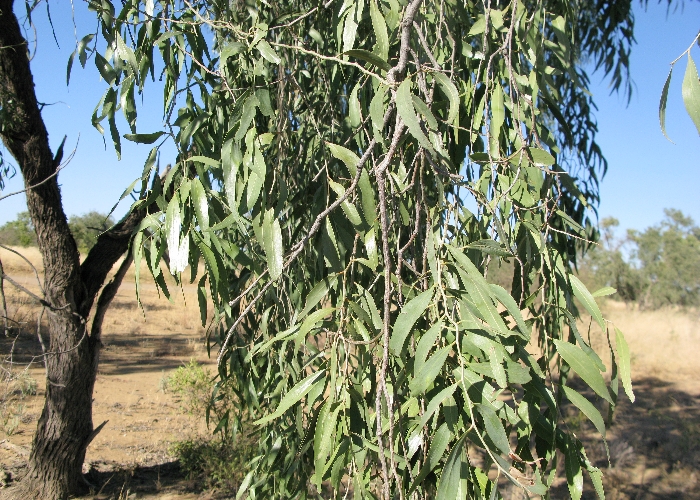
| Description:Trunk | Description:Flowering tree in habitat | |
| Location:10K N of the Lynd, North Queensland | Location:86K N of Bourke, New South Wales | |
| GPS coordinates:18°49.6450S, 144°34.8250E | GPS coordinates:29°22.9720S, 145°50.7720E | |
| Date of photo:22 September 2018 | Date of photo:29 October 2018 | |
| Field No.:6720 | Field No.:7610 | |
| Atalaya hemiglauca | Atalaya hemiglauca | |
|
|
|
|
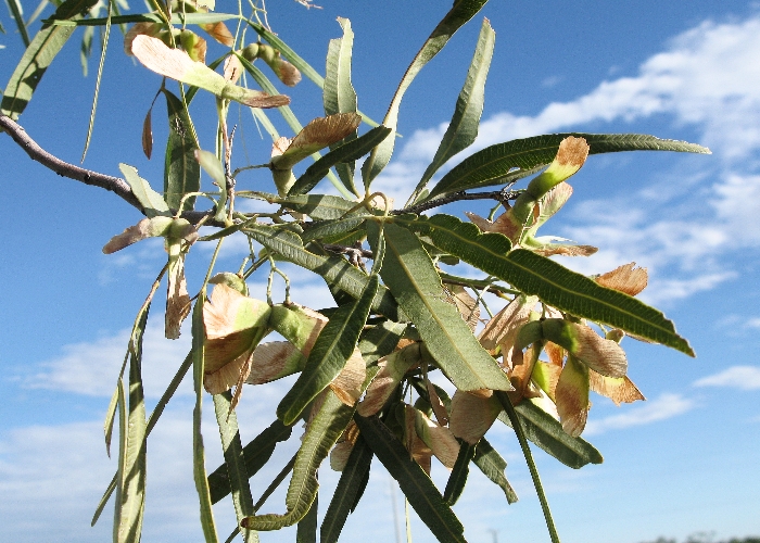
| Description:Seedpods | Description:Tree with seedpods | |
| Location:Landsborough Highway, Longreach, Western Queensland | Location:Landsborough Highway, Longreach, Western Queensland | |
| GPS coordinates:23˚22.0989S, 144°11.5201E | GPS coordinates:23˚22.0989S, 144°11.5201E | |
| Date of photo:25 November 2008 | Date of photo:25 November 2008 | |
| Field No.:U860 | Field No.: U860 | |
| Atalaya hemiglauca | Atalaya hemiglauca | |
|
|
|
|
| Description:Leaves | Description:Tree | |
| Location:Hughenden, North Queensland | Location:Landsborough Highway, Longreach, Western Queensland | |
| Location:10K N of the Lynd, North Queensland | GPS coordinates:23˚22.0989S, 144°11.5201E | |
| Date of photo:26 June 2008 | Date of photo:25 November 2008 | |
| Field No.: U861 | Field No.: U860 | |
| Atalaya hemiglauca | Atalaya hemiglauca | |
|
|
|
|
| Description: Leaves | Description:Tree with mistletoe Dendropthoe glabrescens (FN:4052) | |
| Location:27K W of Normanton, North Queensland | Location:27K W of Normanton, North Queensland | |
| GPS coordinates:17˚47.9436S, 140°52.1418E | GPS coordinates:17˚47.9436S, 140°52.1418E | |
| Date of photo:8 July 2016 | Date of photo:8 July 2016 | |
| Field No.: 4053 voucher specimen | Field No.: 4053 voucher specimen | |
| Host to Dendropthoe glabrescens | Host to Dendropthoe glabrescens | |
Image use policy 
This work is licensed under a
Creative Commons Attribution-Noncommercial 2.5 Australia License.
Page created 5 March 2017
Page edited 18 November 2018
© Roger Fryer and Jill Newland 2017 - 2018